
The San Andreas Fault stretches across California like a massive scar, silently crafting the state’s dramatic topography while holding the potential for devastating earthquakes. This 800-mile geological wonder marks the meeting point of two enormous tectonic plates, engaged in a slow-motion ballet that has captivated researchers for decades and continues to present significant challenges for California’s residents.
The Geological Wonder Beneath California
A Unique Transform Fault
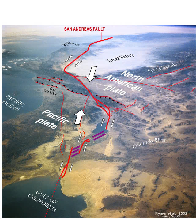
What makes the San Andreas Fault exceptional is its nature as a transform fault where the Pacific Plate and North American Plate slide horizontally against each other. This grinding movement occurs at approximately 2 inches annually—comparable to the growth rate of human fingernails. While seemingly minimal, over millions of years this motion has sculpted California’s iconic landscapes, from soaring mountain ranges to lush valleys.
Rather than a single, clean fracture, the San Andreas is an intricate system of interconnected fault zones extending from Southern California’s Salton Sea to Cape Mendocino in the north. Its existence illustrates Earth’s dynamic character, offering geologists an unparalleled natural laboratory for studying plate tectonics in real-time.
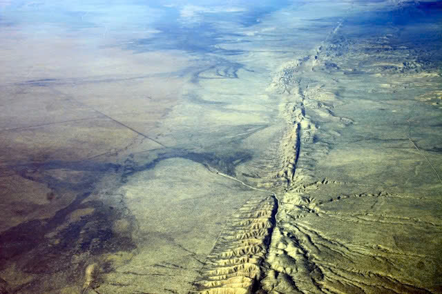
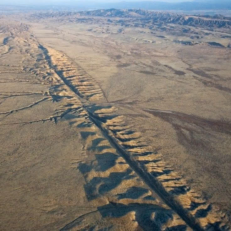
Visible Traces in the Landscape
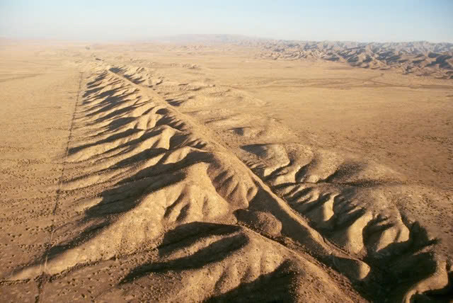
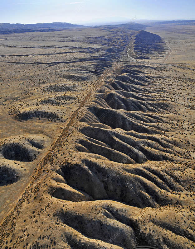
The Carrizo Plain provides one of the most striking displays of the fault’s presence, where visitors can observe the physical manifestations of tectonic forces at work. The ground bears distinct marks of previous ruptures, with noticeable displacements in streams and ridgelines that have shifted over centuries. The towering San Gabriel and Tehachapi Mountains stand as impressive monuments to the immense forces operating beneath California’s surface.
Historic Earthquakes: When the Earth Shook
The 1906 San Francisco Disaster
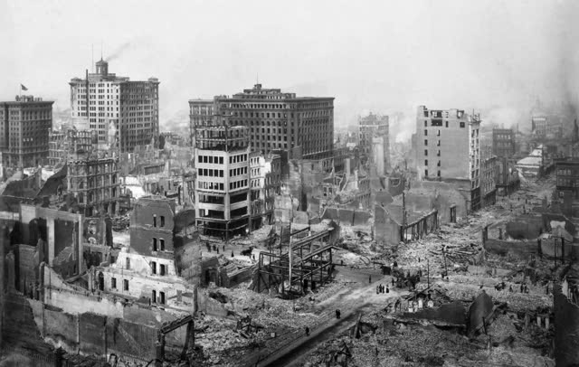
At 5:12 a.m. on April 18, 1906, San Francisco residents were awakened by what would become a pivotal moment in scientific history. The catastrophic 7.9 magnitude earthquake that devastated the city wasn’t merely a humanitarian tragedy—it provided essential evidence that would later help scientists develop the theory of plate tectonics.
The earthquake ruptured nearly 300 miles of the fault, causing ground displacement of up to 20 feet in certain areas. Beyond the immediate destruction, this event fundamentally transformed our understanding of Earth’s structure and behavior.
Other Notable Seismic Events
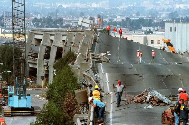
The 1857 Fort Tejon earthquake, also measuring 7.9 in magnitude, demonstrated the fault’s destructive capacity in Southern California. More recently, the 1989 Loma Prieta earthquake (6.9 magnitude), which interrupted a World Series baseball game, served as a powerful reminder that the fault remains active and hazardous.
The Countdown: Current Status and Future Hazards
Concerning Quietude in Southern California
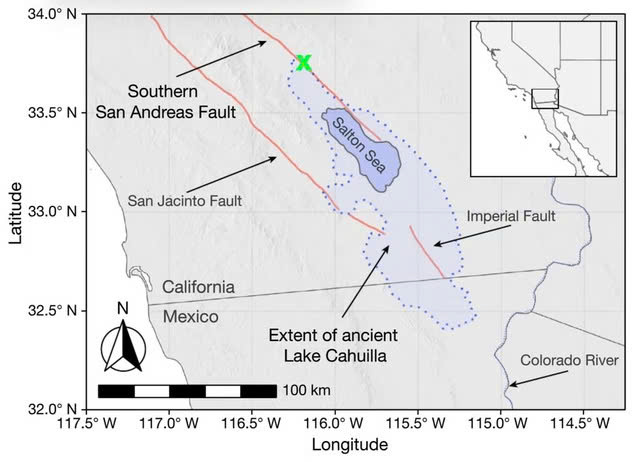
Scientists have become increasingly worried about the southern section of the San Andreas Fault, which has remained unusually silent for more than 300 years. Historical patterns indicate major earthquakes typically occur in this region approximately every 180 years, suggesting this section is substantially “overdue” for a significant release of accumulated stress.
Research has uncovered an intriguing relationship between the Salton Sea’s water levels and seismic activity along this southern section. Rising water levels can literally bend the Earth’s crust and increase pressure within the fault system, potentially triggering earthquakes.
Video
Living with Geological Uncertainty
California’s relationship with the San Andreas Fault resembles a high-stakes waiting game. While seismologists continue monitoring for warning signs, residents and urban planners work diligently to prepare for the inevitable. The state has implemented some of the world’s most stringent building codes and invested heavily in retrofitting infrastructure to withstand major seismic events.
Public awareness campaigns encourage Californians to secure furniture, prepare emergency supplies, and develop family evacuation plans. Meanwhile, early warning systems provide valuable seconds of notice before shaking begins—potentially enough time to take cover or automatically shut down critical systems.
Embracing Life Alongside a Geological Giant
The San Andreas Fault serves as a humbling reminder of our planet’s raw power. While it poses substantial risks, it has also shaped California’s breathtaking landscapes and contributed immeasurably to our understanding of Earth’s processes.
As research advances and preparation technologies improve, Californians maintain their resilient spirit, acknowledging that living alongside this remarkable geological feature means accepting both its beauty and its danger. The fault’s future remains uncertain, but one thing is clear: the San Andreas will continue its gradual transformation of California’s landscape for millions of years to come, one inch at a time.